Introduction: From Cameras to Smart Graphics
In the ever-evolving landscape of smart cities, managing traffic effectively has become a top priority. One of the most innovative solutions is the use of computer graphics in real-time traffic monitoring systems. By visualizing traffic flow, congestion points, and accident zones in intuitive and interactive formats, authorities can make quicker, data-driven decisions.Computer graphics are no longer just for animation or entertainment—they’re now central to public infrastructure, safety, and urban planning.
The Role of Graphics in Traffic Monitoring Systems
Computer graphics contribute to traffic monitoring in several transformative ways:1. Visual Dashboards for Traffic Controllers
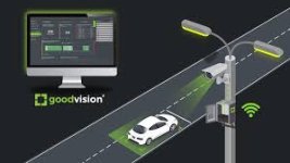
Instead of sifting through raw data or grainy surveillance footage, traffic controllers now rely on graphical dashboards with live simulations of roads, vehicle density, and route efficiency.2. Heatmaps and Flow Diagrams
Traffic intensity is represented through dynamic heatmaps, where color coding quickly indicates areas of congestion or free flow.3. 3D Intersection Modeling
Busy intersections are often simulated in 3D environments that allow planners to test signal timings, pedestrian zones, or bus lanes before implementation.4. Predictive Visualization
By integrating AI with graphics, systems can predict upcoming traffic build-up and visualize potential congestion scenarios before they happen.
How It Works: From Data to Display
Here’s how real-time traffic visualization using computer graphics generally functions:
- Data Collection – Sensors, GPS devices, and CCTV cameras collect movement data.
- Processing – This data is processed through AI and traffic analysis software.
- Rendering – The insights are then visualized using 2D or 3D computer graphics.
- Display – Outputs are shown on command center screens, apps, or public signs.
Tools and Technologies Involved
- GIS Software (like ArcGIS) – For mapping and geospatial visualization
- 3D Engines (e.g., Unity, Unreal Engine) – To create interactive environments
- WebGL & D3.js – For browser-based real-time visualizations
- Simulation Software (e.g., SUMO, VISSIM) – For virtual traffic modeling and testing
Benefits of Graphic-Based Monitoring
- Quick Decision-Making – Visual cues accelerate understanding and action
- Predictive Planning – Helps in forecasting and avoiding future gridlocks
- Public Awareness – Communicates traffic status clearly to the public
- Incident Management – Detects and visually flags accidents in real time
- Environmental Impact – Visual analysis aids in reducing unnecessary idling and emissions
Challenges to Consider
- Data Overload – Visual systems need to filter essential information without overwhelming users
- Accuracy – Graphics rely on the quality and speed of incoming data
- Infrastructure Costs – Setting up integrated visual monitoring systems can be expensive
- Cybersecurity – Protecting visual data streams and control systems is critical
Future Scope: Smarter, Safer Cities
With the rise of autonomous vehicles, smart traffic lights, and vehicle-to-infrastructure (V2I) communication, the use of computer graphics will continue to expand. Expect AR-based navigation for drivers, live 3D city maps for planners, and immersive simulations for emergency planning.
Ultimately, real-time graphics will not only reduce traffic jams but will also help build safer, more responsive urban environments.
Join the Conversation
Have you ever used a traffic app that visualized your route in real time?
Do you think real-time graphics can reduce traffic-related accidents and stress?
What improvements would you like to see in city traffic monitoring?
Let us know your thoughts in the comments!