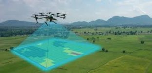
The integration of computer graphics with drone technology has transformed wildlife monitoring into a highly visual and data-rich process. Among the most impactful innovations is the use of advanced graphic maps generated by drones to track, analyze, and protect wildlife populations. These visually enhanced systems combine aerial imaging, geospatial data, and real-time rendering to support ecological research and conservation initiatives.
Traditionally, wildlife monitoring was carried out using field surveys, camera traps, or satellite imaging. While effective, these methods had limitations in terms of coverage, accessibility, and real-time response. With the arrival of drones equipped with high-resolution cameras and GPS capabilities, conservationists can now collect vast amounts of data from previously inaccessible terrains. However, it is the power of computer graphics that turns this raw data into meaningful insights.
Advanced graphic maps allow researchers to visualize animal movement patterns, migration routes, and habitat usage in rich detail. These maps incorporate multiple data layers—topographical features, vegetation types, water sources, and animal positions—allowing experts to understand the complex interactions within an ecosystem. Graphics such as heat maps, 3D terrain modeling, and animated overlays enable scientists to make data-driven decisions.
One key application is in tracking endangered species. Drones capture footage of animals in their natural habitats, and computer graphics software processes this footage to identify species, estimate population densities, and monitor behavioral patterns. For instance, conservationists monitoring elephants or big cats can use thermal imaging data and map overlays to pinpoint poaching hotspots and deploy countermeasures proactively.
The use of computer graphics also simplifies communication between conservation teams, governments, and the public. Instead of complex spreadsheets or raw drone feeds, stakeholders can view interactive dashboards with dynamic maps, charts, and visual reports. This enhances transparency and supports informed decision-making in conservation policy and funding.
Moreover, AI-powered image recognition tools are often integrated with computer graphics systems to automatically label and track animals in the captured footage. These tagged visuals feed into dynamic maps that update in real time, showing movement trends, health indicators, or threats to the animals. Such automation reduces manual labor while improving accuracy.
In remote areas where infrastructure is limited, drones equipped with offline mapping systems can generate 3D topographic graphics, helping researchers navigate and study critical habitats without continuous internet access. These maps are later synchronized with central databases for broader analysis.
Apart from animal tracking, graphic-enhanced drone data is used to monitor environmental changes like deforestation, water pollution, and seasonal vegetation shifts. When combined with historical data, graphic maps can show time-lapse visuals of ecosystem evolution, highlighting areas in urgent need of protection.
The benefits also extend to education and public awareness. Conservation organizations create compelling 3D visualizations and virtual tours using drone-collected data to showcase their work. These engaging visuals make it easier to educate the public and inspire support for conservation efforts.
However, challenges remain. Creating accurate and meaningful graphic maps requires skilled professionals and high-end software. Additionally, drone flights may sometimes disturb sensitive species if not operated responsibly. Balancing data collection with ethical wildlife practices is essential.
In conclusion, advanced graphic maps in wildlife monitoring drones have opened a new frontier in conservation technology. By transforming complex data into easy-to-understand visuals, computer graphics empower researchers, policymakers, and the public to protect biodiversity more effectively. As drone and graphic technologies continue to evolve, the future of wildlife conservation will become increasingly visual, informed, and collaborative.
Join the Conversation:
Have you ever seen drone footage used in wildlife documentaries or conservation campaigns?
Do you think visual data can help more people understand environmental issues?
What ethical considerations should we keep in mind when using drones in the wild?
Let us know your thoughts in the comments!