Computer graphics have emerged as a powerful ally in the global effort to protect wildlife and preserve biodiversity. From tracking endangered species to visualizing migration patterns, graphics-driven tools and technologies have become essential in wildlife conservation and species mapping. These advancements are reshaping how scientists, conservationists, and policymakers understand, monitor, and manage ecosystems around the world.
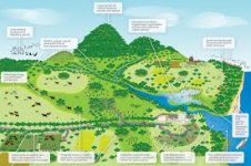
One of the most critical applications of computer graphics in this domain is Geographic Information Systems (GIS). GIS platforms utilize layered visual data—generated through computer graphics—to display topographical, ecological, and species distribution information. These tools allow researchers to create highly detailed species maps that highlight animal habitats, migration routes, and changes in population density over time. Such visual data is crucial for identifying areas that need urgent protection or intervention.
In the field, conservationists use drones and satellite imagery to collect vast amounts of visual data. Computer graphics are then employed to process, analyze, and represent this data in an intuitive, visual format. For example, mapping the habitats of tigers in India or orangutans in Borneo becomes much easier with 3D topographical maps, heatmaps, and animated overlays showing animal movement over weeks or months. These visualizations help bridge the gap between raw data and actionable insights.
Wildlife tracking technologies such as GPS collars on animals generate real-time data that can be visualized through dynamic computer graphics dashboards. These graphics make it possible to observe individual or group behavior patterns, feeding areas, breeding zones, and human-animal conflict regions. Conservation teams can then make data-backed decisions—like restricting access to sensitive areas or relocating endangered animals.
Species mapping through computer graphics also assists in climate change modeling. As temperatures rise and habitats shift, these tools predict how animal ranges will be affected in the future. For instance, a bird species that thrives in cooler mountain zones might lose its habitat due to warming trends. Graphics-based modeling tools can simulate such scenarios, helping conservationists prepare strategies like creating ecological corridors or artificial habitats.
Another essential area is public engagement and education. Interactive graphics, documentaries using CGI, and immersive simulations allow people to explore forests, oceans, and savannahs virtually. These tools increase awareness of the importance of conservation and motivate public participation in preservation efforts. Augmented reality (AR) and virtual reality (VR) experiences powered by computer graphics can recreate endangered species in lifelike detail, bringing them closer to people who may never encounter them in the wild.
In academic and research settings, species mapping and ecological modeling using computer graphics are integral to biodiversity studies. The visualization of complex datasets allows students and researchers to identify patterns, correlations, and anomalies that might be invisible in numerical form. This fusion of ecology and computer graphics enhances the quality and reach of environmental research.
Despite the promise, challenges persist. The accuracy of visual data depends on the quality of input, and errors in mapping or graphic representation can lead to flawed conservation strategies. Therefore, integrating field validation with digital visualization remains crucial. Moreover, the high cost of advanced graphics systems and training can be a barrier for small conservation projects or developing nations.
In conclusion, the use of computer graphics in wildlife conservation and species mapping is transforming environmental science. It empowers experts with visual tools that enhance understanding, decision-making, and communication. As technology continues to evolve, the integration of AI with graphics will further refine predictions and conservation strategies, offering hope for a more sustainable coexistence between humans and nature.
Join the Conversation:
Have you seen any wildlife documentaries that use stunning computer graphics?
Do you think visual tools help people care more about endangered species?
What more can be done using graphics to support conservation?
Let us know your thoughts in the comments!